1·
16 小时前Apparently I don’t know the right string to ping you on the other thread, but its up now. I think the final waterfall/rapid is the one you referred to, at the boundary area of the wilderness.
Apparently I don’t know the right string to ping you on the other thread, but its up now. I think the final waterfall/rapid is the one you referred to, at the boundary area of the wilderness.
u/ikidd I believe the final waterfall pictured is the one you mentioned as having the campground. Its right by the boundary of the wilderness area. Definitely not the same as what I originally thought.
Yeah, I continued on to just past the hill with the ropes to get up and then turned around after seeing that viewpoint of the long rapid/falls. Seems like it gets pretty wild from there on. Tomorrow I’ll post a group of photos from that section beyond the main falls. Although I couldn’t get a photo I like, I think my favorite section was half a mile or less beyond the main falls where that huge wedge rock is getting cut by the river before you start to climb again. I believe that is where the camping may also be. IIRC one of the falls I’ll post tomorrow is just upstream of it. That and the bridge, I love pedestrian bridges haha.
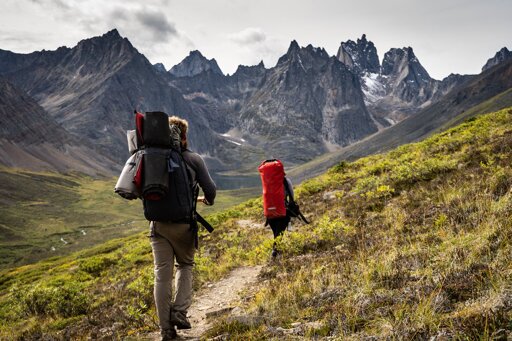
Thanks, I appreciate it! Yeah, since it’s mostly all trail photos that I take, I enjoy placing people at a distance for scale if I’m trying to include the route. Today’s post has a pretty good one as well that I liked.
That sounds like a good adaptation they’re making, even just greater cell phone access is probably making that worse as well. I’ve definitely had park people scoff at me when bringing up AllTrails in the past, which is usually when I scratch that one off the list of to do’s. AllTrails also shouldn’t be encouraging shortcuts when switchbacks are there for a reason.
I’m sure this is preaching to the choir, but preparation beforehand goes so far too. It never ceases to amaze me how unprepared people are willing to go without even a set idea of where they want to be. I remember one time being at the high point of the High Divide trail in Olympic NP, WA and out of nowhere this panicked kid comes up to me asking for directions. This trail is 19 miles and 5k ft as a dayhike (people usually overnight or two) and he had just pushed on with some girl that was waiting down below a bit. This was at the halfway point so either way would’ve been fine, but he basically bailed before I could adequately explain anything. There’s a short loop of maybe 6 miles that I’m sure was what he meant to do, but how do you go ten miles on a six mile loop without turning around?
Yeah, I’ve already been lukewarm on how they go about their trail data, as stressed by park rangers and this article, but overall that app has been a huge benefit for me. To me, this is likely the one step too far. One year to ween myself off of it before the subscription lapses.
The card says ‘moops’… fixed, thanks
Well , that’s unfortunate. My subscription that I was on the fence about anyways renewed about 10 days ago. Their tracking beats anything else I know of. Garmin Connect is not my favorite UI, but it’ll work.
Yeah, as posted above, its in the Canadian Rockies.
Would love to do the whole thing someday. Super jealous of the 2018 trip you had. Yeah, I’d like to see photos with before/after.
Oops, yeah somehow I had it as whitehorn mtn, whitehorse cg, and white falls (which i believe is still correct). Thought that was a bit much. Glad I was wrong.
No, it’s something I’ve noticed too as I’m seeing them posted. Think I need to adjust display settings on the monitor because they seem less so on it, and generally just get better at it as well. Thanks for the advice!
Yeah, i’m still learning darktable so some of these images may still come out looking a bit odd on the post processing. I’m likely to go back through each of the ones i already uploaded to flickr and reupload better processed ones now that I’m getting a better handle on the software, because there are some that I feel already look much better after a second pass.
As for the over-exposure on these, yeah I got a newer lens over the winter and when I got there I realized I never got any ND filters for it so I was just dealing with the sun. I tried playing with the images but found that I could never find anything that made me happy, and I didn’t think the original image was good enough to dig too deep into it if I’m being honest. The waterfall itself is doing all the heavy lifting on that one haha.
Long story short, the processing should improve over time but I thank you very much for the advice.
Thanks! Those are some good photos as well! Yeah, I considered doing green mtn lookout as I was passing through, but ended up not doing it. Think I was more interested in getting a shower in clearwater at that point or something haha, maybe next time. Pretty sure that road to Trophy mtn was still closed at the time but it also sounded like a good one.
I’m hoping I can pull that off in two years, definitely on the list. This is my first trip to Canada and absolutely love it so far.
Thanks! Glad you like them. I’ll be posting one trail a day like this for the foreseeable future. May miss a day or two if I don’t reach cell service but outside of that I should be good. I’ve got two months of canada hikes with one more month up here, plus 1,000 miles worth of trails from last year that I still need to deal with, so I should be able to keep it going for a while… The plan is to get trail write-ups for everything I do put up on a blog I’m trying to get going, but learning wordpress while spending the majority of your time in the woods is difficult haha. It’s gotten to the point that I need to just start putting some this out there though, and hope that spurs me forward on the rest.
HQ versions of all of these are up on flickr.com/everydayhiker/ as well, with more photos for every trail.
Thanks, appreciated. I figured something like that was what was needed, but unsure where. Have a good one!


Damn, that is wild. Agree on the cats, they worry more than anything and I’ve rarely ever even seen any. I had wondered if many people went out that way as a backpacking trip, but I’d say you filled it in really well. Thanks!